Old Irish maps are an essential resource for Irish family historians and genealogists.
Want to locate your ancestral home, parish church, or nearest market town? Or explore the roads that rose to meet your ancestors' footsteps back in the day?
Here's our guide to the best maps for Irish family history research ...

Ireland – the first country in the world to be mapped in detail
Did you know that the first-ever detailed land survey on a national scale, anywhere in the world, was taken in mid-17th-century Ireland? In the early 19th century, Ireland also became the first country in the world to undergo a detailed ordnance survey. And the good news is these maps have been digitized and can now be accessed online... for free!
Old Irish maps are not just for archaeologists, geographers, and historians. When it comes to locating the places where our ancestors lived in Ireland, these historical maps can point us to homesteads long gone, surname clusters, and more.
Historical maps can help identify old placenames, boundary changes, neighboring relatives, the effects of the Great Famine, and other insights into our ancestors' lives.
Specialised maps (e.g. civil parish, church & diocese, or workhouse PLU) can help us make sense of the clues our ancestors left behind.
This guide will help you discover the best maps for Irish family history research, and how to navigate them.
Don't forget, you can also jump on our Local Volunteer Message Board for help making sense of Irish maps, old and new.
1: First Atlas of Ireland 1657
Explore your ancestral county just after Cromwell. Discover surnames connected to the land before the rebellion, alternative placename spellings, and how it was settled before and after (English vs Irish speakers).
Hiberniae Delineatio, the first atlas of Ireland, was created in the 17th century following the Cromwellian conquest of Ireland (1649–53).
-
The Down Survey of Ireland (1656-1658) mapped by William Petty, sought to measure all the land to be forfeited by the Catholic Irish in order to facilitate its redistribution to new landlords (merchant adventurers and English soldiers).
-
Trinity College Dublin (TCD) has digitized all surviving Down Survey maps and made them available as a free online resource.
> VIEW Down Survey Maps
2: First Route Maps of Ireland 1777
See your ancestral town or village (and the routes between them) in Penal times. Discover houses, churches, inns, and other landmarks in their heyday.
Taylor and Skinner’s Maps of the Roads of Ireland are an essential local history research tool for the late 18th century. Published in two editions (1777 and 1782) the book contains 288 pages of beautifully engraved maps, highlighting placenames, churches, castles, inns, gentleman’s seats, native Irish settlements, and more.
> VIEW Taylor & Skinner Road Maps
3: Lewis' Maps – your county before the famine 1837
Discover your ancestral county in exquisite detail when the roads were few and winding. Revisit the landscape your ancestors knew before the Great Irish Famine (1845-52) changed it forever.
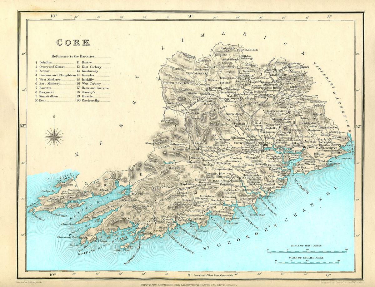
Lewis' Topographical Dictionary of Ireland is one of the most valuable and unique sources of local history in Ireland. The equivalent of a tourist's "Lonely Planet Guide" in its day, it came with an accompanying atlas of exquisite county maps. If you fancy adorning your wall with your ancestral county map, the L Brown Collection offers high-resolution sepia Lewis Map prints.
> VIEW Your County before the Famine
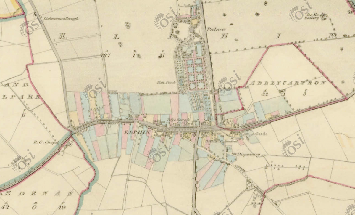
4: First Ordnance Survey of Ireland 1829-1842
These 6-inch OS maps are an unrivaled source for the period immediately before the Great Irish Famine. Their significance for Irish family history research cannot be overstated.
This early 19th century Ordnance Survey of Ireland (OSi) was the first complete survey of Ireland since Petty's Down Survey. Acclaimed by cartographers for its accuracy, it was also the first-ever large-scale ordnance survey of an entire country anywhere in the world.
FIND OUR CONTENT USEFUL? PLEASE DONATE HERE, EVERY LITTLE HELPS
Working from north to south, the survey began in Antrim and Derry in 1829 and was completed in Kerry in 1842. From 1838, even field boundaries were included in the surveys.
For dating an OS map see: UCD's Historic OS Maps USER GUIDE
The maps details include:
Placenames Baronies, civil parishes, townlands, cities, towns, villages, bays, and harbors, rivers, gentlemens’ seats (aka big houses), bog names, loughs, woods, islands, hills, bridges. Boundaries Townlands, civil parishes, baronies, counties, municipal wards.
Settlement Towns, villages, fairgrounds, public buildings, schools, chapels (Roman Catholic and Presbyterian), churches, meeting houses, institutions, hospitals, workhouses, dispensaries, inns, wells, post offices, constabulary and army barracks, almshouses, gasworks, graveyards, spas, racecourses, bathing places, antiquities (forts, raths, standing stones, moats, motes), ruined buildings.
Agricultural Features Farm houses and buildings, field boundaries, blacksmiths, lime kilns, demesnes, orchards, gardens, plant nurseries, drainage channels, sluices, and fish ponds. Topographical Features Rivers, streams, lakes, waterfalls, rapids, cliffs, rock outcrops, hilltops, caves. Vegetation Features Fir plantation, mixed wood, brushwood, rocky or heathy pasture, marsh, bog, furze, the limit of cultivation. VIEW Characteristic Sheet
Industrial Features Factories, foundries, mills (beetling, corn, flour, flax, gig, paper, and tuck), windmills, ponds, bleach greens, ropewalks, tanneries, breweries, distilleries, quarries, sand and gravel pits, colliers, mines, brickfields, weirs and dams, millraces, fisheries. Transport Roads, lanes, bridges, fords, canals and locks, aqueducts, railways and stations, ferries, harbors, piers, and mooring posts.
LEARN MORE
Charles Close Society A short History of the Ordnance Survey in Ireland.
National Archives of Ireland NAI Guide to the Records of the Ordnance Survey

The spelling of Irish placenames (such as townlands, parishes, and towns) was standardized by these maps. During this process, John O'Donovan recorded a lot of each placename's history. (For example, Lehinch aka Lahinch was sometimes recorded as Lahensy/Lahinchy and more). DISCOVER alternative names and spellings on logainm.ie under "Archival Records".
The first edition of these maps (and additional mapping data) can be explored free online via OSi (Ordnance Survey Ireland) and OSNI (Ordnance Survey of Northern Ireland).
-
OSI's GeoHive MAP VIEWER provides free, web-based access to Ordnance Survey Ireland and other geospatial datasets. For OS 6-inch and 25-inch County Series historical maps see its National Townland and Historical Map Viewer.
-
OSNI's Spatial NI MAP VIEWER aka PRONI Historical Maps Viewer allows access to Ordnance Survey maps and other geospatial information for Co. Antrim, Co. Armagh, Co. Down, Co. Derry ~ Londonderry, Co. Fermanagh, and Co. Tyrone.
-
UCD's Historic OS Maps USER GUIDE helps you navigate these resources (including how to find an old OS map's survey date).
> VIEW GeoHive MAP VIEWER | NI Spatial MAP VIEWER
5: Griffith's Valuation Maps of Ireland 1847-1864
Match a property on a map to a name recorded in Griffith's Primary Valuation and vice versa.
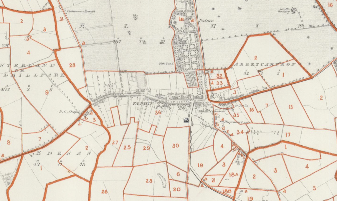
The 6-inch OS maps were used as a basis for the Primary Valuation of Ireland aka Griffith’s Valuation – Ireland's first full-scale valuation of property for taxation purposes. Griffith’s Valuation Ratepayer lists (circa 1844-1865) were matched to each property (by number and letter) on these maps and can be searched online at AskAboutIreland. Searches can be made by surname or placename. Unpublished town plans are also available when viewing the maps (click on "show towns").
Map revisions: When the first edition of OS maps was completed in 1846 the counties of Antrim, Armagh, Derry, Donegal, Down, Fermanagh, Monaghan, and Tyrone were resurveyed to add field boundaries. And this general revision was extended to other counties due to changes in the post-famine landscape.

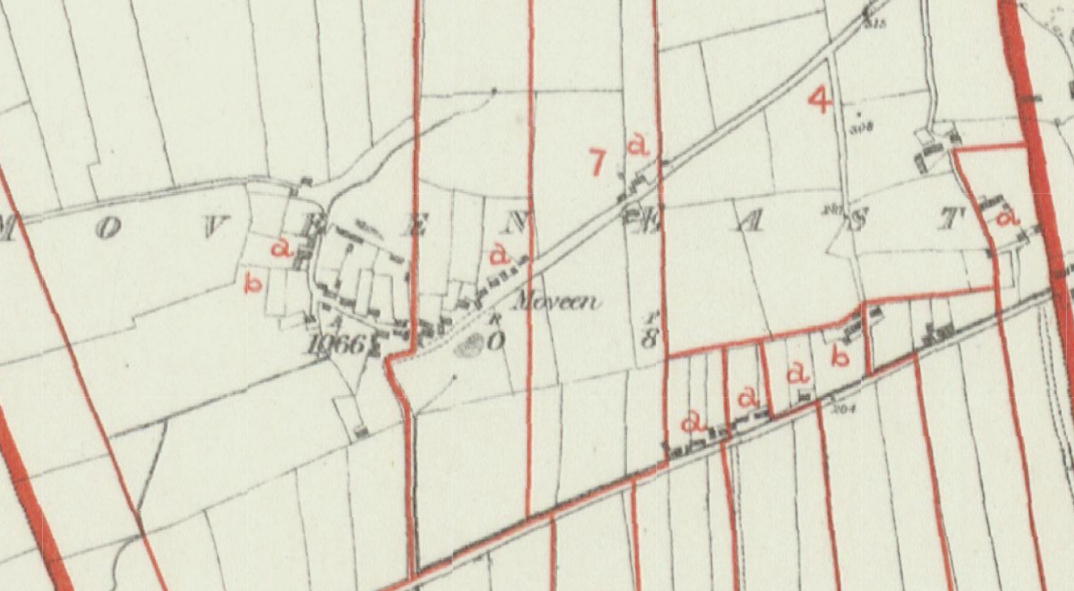
Villages wiped out by the famine (such as Moveen, Co. Clare depicted below) are revealed by the dearth of letters attached to homes mapped (a decade earlier in the first OS survey). Only the homes still inhabited at the time of Griffith's post-famine valuation made the ratepayer's list. Those unmarked can be presumed to be "down" or used as outbuildings.
> VIEW Griffiths Maps on AskAboutIreland
6: 25-inch Series OS Maps 1893-1913
These 25-inch OS maps can be used to locate properties attached to names recorded in the Irish Census of 1901 & 1911.
Revision of the 6-inch maps ended in 1887 when the government agreed to survey the country at the larger scale of 1:2,500. Key search fields in the census are also recorded and searchable on the Geohive mapping website. Street names and locations such as Townland names are common to both datasets and can be cross-referenced. Click on "Historic Map 25-inch" to view and compare.
> VIEW GeoHive MAP VIEWER | NI Spatial MAP VIEWER
Navigating Irish Maps

Much like Ireland's infamous road signage, navigating Irish maps can be a challenge for Irish genealogy research. Before delving into Irish maps, it helps to understand the terms used for land divisions in Ireland:
- Counties – a key source of Irish self-identification at home and abroad – did not come into existence all at once. There are 32 counties on the island of Ireland (map resource providers may only cover the 26 counties of the Republic of Ireland or the 6 counties of Northern Ireland in some cases). Family historians should take note of alterations to county borders in 1898 and name changes in 1922 (from Queen's County to Co. Laois, and King's county to Co. Offaly).
-
Baronies are larger subdivisions of a county that can serve as a vital location marker for civil parishes that share identical names (yes, this can happen within the same county). Most counties have a barony within them of the same name. Interestingly, Irish barony divisions were based on Gaelic Kingdoms or tuath (e.g. the Barony of Boyle was originally McDermott territory) and Cromwell organised his Plantation settlements (Scots or English) by barony. There are 327 baronies in Ireland.
-
Civil parishes were administrative units of territory (formalized by Cromwell's Plantation of Ireland). A townland's civil parish is a vital marker for its location (as a county or barony can contain numerous townlands of the same name). There are 2,509 civil parishes in Ireland (some with identical names). LEARN MORE What is a parish?
-
Townlands are the smallest subdivision of a geographical division of land in Ireland. They are of no small importance to the family historian because they can provide a traceable address to the present day, especially for ancestors who lived in rural or less populated areas. There are 61,118 townlands in Ireland (many with identical names). LEARN MORE What is a townland?
Navigation Tools
- Shane Wilson's Townland Index & Database helps identify the correct civil parish (and eliminate records that turn up for townlands of the same name in other parishes).
- Logainm.ie is your GO TO website for confirming a townland's correct spelling, the original Irish language version, and local pronunciation. (It's also handy for mapping to the nearest town).
- MAPS: Townlands.ie shows full boundary outline and also lists adjoining townlands (a must for townlands that sit close to a civil parish boundary).
- Bing Maps and Google Street View help match townland names on modern maps.
- Brian Mitchell's A New Genealogical Atlas of Ireland, 2nd Edition, is a key resource in Irish genealogical research and contains maps detailing the location of Roman Catholic parishes in all 32 counties.
Irish Parish Maps & more
John Grenham Catholic Parish Maps | Poor Law Union (Workhouse) Maps | Civil Parish Maps
Great Famine Maps | NLI Catholic Parish Maps | Shane Wilson's Historic Maps
The Irish Historic Towns Atlas | UCD Digital Library | LeslieBrownCollection
National Library of Ireland (NLI) | Royal Irish Academy (RIA)) | Oireachtas Library Maps
Dublin Historic Maps | Jisc Library Hub Discover | OpenStreetMap (OSM)
British Library | National Archives - Kew | National Library of Scotland
ALSO READ
We hope you have found the information we have shared helpful. While you are here, we have a small favour to ask. Ireland Reaching Out is a non-profit organisation that relies on public funding and donations to ensure a completely free family history advisory service to anyone of Irish heritage who needs help connecting with their Irish place of origin. If you would like to support our mission, please click on the donate button and make a contribution. Any amount, big or small, is appreciated and makes a difference.